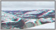
Cisco Butte is a small peak west of Donner Summit. During the last ice age,
glaciers filled the valley below to a depth of 1500 feet. This peak is only 1100
ft. above the river below, so the glaciers rode up and over it, coming toward
the camera, leaving grooves on the top of the peak. When the ice melted, it
dropped whatever it was carrying, including this twenty foot granite boulder,
called a glacial erratic. This and numerous others are visible in Google Earth.
I had hoped to match a Alfred A Hart stereo from the 1860?s, but will have
to wait until some of the snow melts this spring to get the exact photo spot. I
was about six feet too high.
Had a nice ski back down, by the way.
Art
 (1423K)
 (195K)